Saunders County NEGenWeb Project

THE SYSTEM OF GOVERNMENT SURVEYS.
|
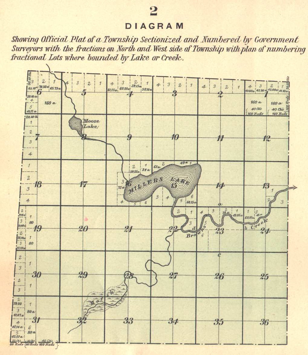
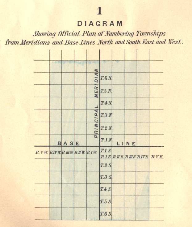
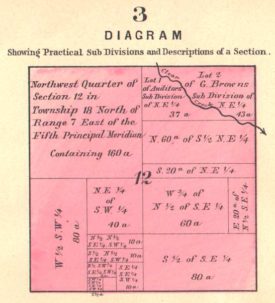
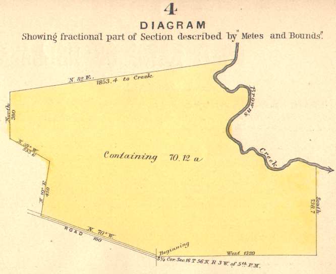
THE present system of surveying Government lands, termed the Land System of the United States, has developed from an ordinance introduced before the Continental Congress May 7, 1784, termed "An Ordinance for ascertaining the mode of locating and disposing of lands in the Western Territory," and adopted by an act of Congress passed May 7, 1785. It had no precedent in the theory or practice of any pre existing government, being the result of the highest order of statesmanship, and exhibiting a profound knowledge of engineering science in minute details. With a few unimportant changes, it has been adopted by the Dominion of Canada. The ordinance provided for townships six miles square, containing thirty-six sections one mile square. The region embraced by the surveys under this law forms a part of the present State of Ohio, and is usually styled "Old Seven Ranges." The townships, six miles square, were laid out in ranges extending northward from the Ohio River, the townships being numbered from south to north, and the ranges from east to west. In these initial surveys only the exterior lines of the townships were surveyed, and mile corners were established on the township lines, but the plats were marked by subdivisions into sections of one mile square. The sections were numbered from one to thirty-six, commencing with number one in the southeast corner of the township, and running from south to north in each tier to number thirty-six in the northwest corner of the township. These first public surveys were made under the direction of the Geographer of the United States. The act of Congress approved May 18, 1796, provided for the appointment of a surveyor-general, and directed the survey of the lands northwest of the Ohio River and above the mouth of the Kentucky River, "in which the titles of the Indian tribes have been extinguished." Under this law one-half of the townships surveyed were subdivided into sections "by running through the same, each way, parallel lines at the end of every two miles, and by making a corner on each of said lines at the end of every mile," and it further provided that "the sections shall be numbered, respectively, beginning with the number one in the northeast section, and proceeding west and east alternately, through the township, with progressive numbers till the thirty-sixth be completed." This method of numbering the sections is still in use, and can be seen by reference to Diagram No. 2, on reverse page. The act of Congress, approved February 11, 1805, directs the subdivision of the public lands into quarter sections, and provides that all the corners marked in the public surveys shall be established as the proper corners of sections or subdivisions of sections which they were intended to designate, and that corners of half and quarter sections not marked shall be placed as nearly as possible "equidistant from those two corners which stand on the same line." The act of Congress, approved April 25, 1812, provided "That there shall be established in the Department of the Treasury an office to be denominated the General Land Office, the chief officer of which shall be called the Commissioner of the General Land Office, whose duty it shall be, under the direction of the head of the department, to superintend, execute, and perform all such acts and things touching or respecting the public lands of the United States and other lands patented or granted by the United States, as have heretofore been directed by law to be done or performed in the office of the Secretary of State, of the Secretary and Register of the Treasury, and of the Secretary of War, or which shall hereafter by law be assigned to the said office." The act of Congress, approved July 4, 1836, provided for the reorganization of the General Land Office, and that the executive duties of said office "shall be subject to the supervision and control of the commissioner of the General Land Office under the direction of the President of the United States." The repealing clause is, "That such provisions of the act of the twenty-fifth of April, in the year one thousand eight hundred and twelve, entitled 'An act for the establishment of a General Land Office in the Department of the Treasury,' and of all acts amendatory thereof as are inconsistent with the provisions of this act, be and the same are hereby repealed." From the wording of this act, it would appear that the control of the General Land Office was removed from the Treasury Department, and that the Commissioner reported directly to the President; but as a matter of fact the Secretary of the Treasury still had supervisory control, for the act of Congress, approved March 3, 1849, by which the Department of the Interior was established, provided "That the Secretary of the Interior shall perform all the duties in relation to the General Land Office, of supervision and appeal, now discharged by the Secretary of the Treasury." By this act the General Land Office was transferred to the Department of the Interior, where it still remains. The public lands of the United States are ordinarily surveyed into rectangular tracts bounded by lines conforming to the cardinal points. The principal lines are designated as meridian, base, township, range, and section lines, and the bodies of land thus formed are known as townships, sections, and lots. The first recorded use of the terms "township," and "section," as applied to the public lands of the United States, is in an ordinance reported to Congress April 26, 1785. In Diagram No. 2, representing an entire township, each "section" and "lot" is plainly indicated. Initial points from which the lines of the public surveys are to be extended must be established whenever necessary under such special instructions as may be prescribed in each case by the Commissioner of the General Land Office. The locus of such initial points must be selected with great care and due consideration for their prominence and easy identification, and must be established astronomically. The initial point having been established, the lines of the public survey are to be extended therefrom as follows:-- Ohio public surveys are controlled by several initial points, and by the first principal meridian coincident with the common boundary between Ohio and Indiana. Indiana surveys are controlled by the second principal meridian. Illinois surveys are controlled by the second, third, and fourth principal meridian. Wisconsin by the fourth principal meridian. Minnesota by the fourth and fifth principal meridian. The Dakotas by the fifth and sixth principal meridians, also by the Black Hills meridian. Iowa, Missouri, and Arkansas by the fifth principal meridian. Kansas, Nebraska, and the greater portion of Colorado and Wyoming by the sixth principal meridian. Michigan by the Michigan meridian. Florida by the Tallahassee meridian. Alabama by the Huntsville and St. Stephens meridians. Mississippi by the St. Stephens, Choctow, and Washington meridians. Louisiana, east of the Mississippi River, by the St. Helena meridian, and on the west by the Louisiana meridian. New Mexico by the New Mexico meridian. Arizona by the Gila and Salt River meridian. Utah by the Great Salt Lake meridian. Nevada by the Mount Dieblo meridian. Idaho by the Boise meridian. Montana by the Montana meridian. California by the Mount Dieblo, the San Bernardino, and the Humboldt meridians. Oregon and Washington by the Williamette meridian. Township lines are run east and west parallel with and six miles from the base line and from each other, and the spaces between these lines are known as townships north or south, and designated by numbers according to their numerical distance from the base line. Range lines are run north and south on a true meridian, six miles from and parallel, as near as may be, with the principal meridian, and the spaces between them are known as ranges, and are described as east or west of the principal meridian, and consecutively numbered from that line. Diagram No. 1, on reverse page, will illustrate the system of numbering townships and ranges, north and south and east and west from the principal meridians and base lines; numbering east or west until they reach the next meridian, and north or south until they reach the next base line. Thus, any certain township or range can readily be found within the territory embraced by this system if the numbers of the same are known referring to principal meridian and base line. The bodies of land six miles square, formed by the intersection of the township and range lines, are called and contain, as near as may be, 23,040 acres. Congressional townships are described and located as being north or south of the base line and east or west of the principal meridian from which that particular survey is made. Thus township one north, range three west of the fifth principal meridian, would be the first township north of the base line and in the third range west from the principal meridian. The law requires that the lines of the public surveys shall be governed by the true meridian, and that the townships shall be six miles square, two things involving, in connection, a mathematical impossibility, for, strictly to conform to the meridian necessarily throws the township out of square by reason of the convergency of the meridians, and hence, by adhering to the true meridian results the necessity of departing from the strict requirements of law, as respects the precise area of townships and the subdivisional parts thereof, the townships assuming something of a trapezoidal form, which inequality develops itself more and more as such the higher the latitude of the surveys. For that reason standards and auxiliaries, which are also called correction lines, and auxiliary or guide meridians are run from time to time, and are designated by number, and as north, south, east, or west, as the case may be, from their respective base lines and principal meridians; parallels and auxiliaries are now run at intervals of twenty-four miles, dividing the country into tracts of twenty-four miles square, or sixteen townships. Congressional townships are subdivided into thirty-six tracts, called each containing as near as may be 640 acres. The thirty-six sections into which a township is subdivided are numbered, commencing with number one at the northeast angle of the township, and proceeding west to number six, and thence proceeding east to number twelve, and so on, alternately, until they number thirty-six in the southeast angle. In all cases of surveys of fractional townships, the sections should bear the same number as they would if the township was full. In all cases where the exterior lines of the townships thus subdivided into sections or half sections shall exceed, or shall not extend, six miles, the excess or deficency shall be specially noted, and added to or deducted from the western or northern ranges of sections or half sections in such township, according as the error may be in running the lines from east to west, or from south to north; the sections and half sections bounded on the northern and western lines of such townships shall be sold as containing only the quantity expressed in the returns and plats respectively, and all others as containing the complete legal quantity. Diagram No. 2, on the reverse page, shows an entire Congressional Township subdivided and numbered by sections, and showing excess or deficiency in area on the north and west sides of the township. Sections are divided into quarters by straight lines run from the established quarter section corners--United States surveys--to the opposite corresponding corners, and the point of intersection of the lines so run will be the corner common to the several quarter sections, or, in other words, the legal centre of the section; these quarter sections are designated as northeast quarter, northwest, southwest, or southeast, according to their location with regard to their common corner. In the subdivision of quarter sections, the quarter quarter corners are to be placed at points equidistant between the section and quarter section corners and between the quarter corners and the common centre of the section, except on the last half mile of the lines closing on the north or west boundaries of a township, where they should be placed at twenty chains, proportionate measurement, to the north or west of the quarter section corner. Fractional sections and those containing meandered rivers and lakes are also divided into 40 acre lots, as near as may be; these fractional lots are numbered from one upwards in each section. By an examination of Diagram No. 2, on reverse page, and of the maps on other pages of this work, the careful student will be enabled to describe or locate any piece of land. Numbers 1, 2-6 are the numbers of the meandered lots with areas shown: a, north quarter corner; b, east quarter corner; c, south quarter corner, and d, west quarter corner. Proceeding down stream, the bank on the left hand is termed the "left bank" and that on the right hand the "right bank." These terms are to be universally used to distinguish the two banks of a river or stream. The original corners, where they can be found, must stand as the true corners they were intended to represent, even though not exactly where strict professional care might have placed them in the first instance. Missing corners should be re-established in the identical localities they originally occupied. When the point cannot be determined by the existing landmarks in the field, resort must be had to the field notes of the original survey. The law provides that the lengths of the lines, as stated in the field notes, shall be considered as the true lengths thereof; and the distances between corners set down in the field notes constitute proper data from which to determine the true locality of a missing corner; hence the rule that all such should be restored at distances proportionate to the original measurements between existing original corners. That is, if the measurement between two existing corners differs from that stated in the field notes, the excess or deficiency should be distributed proportionately among the intervening section lines between the said existing corners standing in their original places. Missing corners on standard township and range lines should be restored by proportionate measurement between the nearest existing original corners on those lines. Missing section corners in the interior of townships should be re-established at proportionate distances between the nearest existing original corners north and south of the missing corners. As has been observed, no existing original corner can be disturbed, and it will be plain that any excess or deficiency in measurements between existing corners cannot in any degree affect the distances beyond said existing corners, but must be added or subtracted proportionately to or from the intervals embraced between the corners which are still standing. Various States require their county auditors or recorders to cause a survey and plat of "irregular tracts" of land to be made and placed upon record, when, for assessment purposes, the descriptions are too indefinite. These become official, and title will pass as the same appears of record, by the number of each lot being given on the plat. Diagram No. 3, on reverse page, shows a practical subdivision of a section for assessment or other purposes, with a proper description of each fractional part of the quarter section. In the Eastern and New England States the system of surveying and describing lands by metes and bounds as followed prior to the establishment of the rectangular system of surveys still exists. The system at its best is imperfect and uncertain in its working, having no known lines for base of surveys, and seldom any official plats for references as to initial points. Diagram No. 4 shows a tract of land described and platted by "metes and bounds," as the same would appear in deeds. What is known as the "new standard time," was adopted by agreement of all the principal railroads of the United States at 12 o'clock, noon, on Nov. 18, 1883. The system divides the Continent into five longitudinal belts, and establishes a meridian of time for each belt. These meridians are fifteen degrees of longitude, corresponding to one hour of time, apart. Eastern Maine, New Brunswick, and Nova Scotia use the 60th meridian; the Canadas, New England, the Middle States, the Virginias, and the Carolinas use the 75th meridian, which is that at Philadelphia; the States of the Mississippi Valley, Alabama, Georgia, Florida, and westward, including Texas, Kansas, and the larger part of Nebraska and the Dakotas, use the 90th meridian, which is that of New Orleans; the Territories to the western border of Arizona and Montana, use the 105th meridian, which is that of Denver; and the Pacific States use the 120th meridian. The time divisions are known as intercolonial, eastern, central, mountain, and Pacific standard time. A traveller passing from one belt to another will find his watch one hour too fast or too slow, according to the direction in which he is going. If travelling westward, his watch will be one hour faster; if eastward bound, it will be one hour slower than the belt which he enters. This change of system reduced the time standards used by the different railroads from fifty-three to five, a great convenience to the railroads and travelling public. The suggestion leading to the adoption of this new system originated with Professor Abbe, of the Signal Bureau at Washington, and was elaborated by Dr. F. A. P. Barnard, of Columbia College, New York. The scheme was proposed in 1878, but was not adopted until it had been submitted to a number of scientific associations at home and abroad, and received their approval. ----------- |

