

Click on the map or use the complete listing of locations below to go to an enlargement of an area.
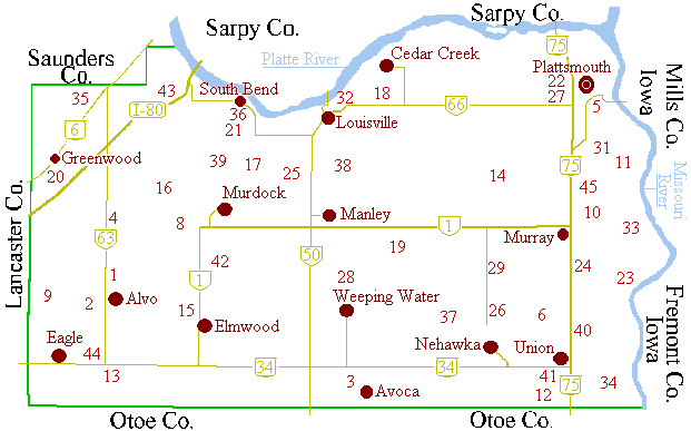
- The above map includes current towns, major roads and numbers marking the locations of cemeteries.
- Click on the map or use the complete listing of locations below to go to an area map that includes more extensive location information.
- Area maps include current towns, major roads, cemeteries, discontinued towns and historical post office designations for rural areas.
Area maps: North-West Cass County | North-East Cass County | South-West Cass County | South-East Cass County
| Cemeteries | ||
|---|---|---|
|
1. Alvo- S.W. 2. Alvo Brethren (Dunkard)- S.W. 3. Avoca- S.E. 4. Belmont- N.W. 5. Billings- N.E. 6. Buck- S.E. 8. Callahan- N.W. 9. Camp Creek (Pleasant Hill)- S.W. 10. Clemmons- N.E. 11. Doom- N.E. --- Dunkard- see Alvo Brethren 12. Dysart-Hoback (Pleasant Grove)- S.E. 13. Eagle- S.W. --- Eaton's- see Sciota 14. Eight Mile Grove- N.E. 15. Elmwood- S.W. 16. Elmwood North- N.W. --- Emmanuel Evangelical- see German Evangelist |
17. German Evangelist (Emmanuel Evangelical)- N.W. 18. Glendale- N.E. 19. Grandview- S.E. 20. Greenwood- N.W. 21. Hill & Worrell- N.W. 22. Holy Sepulchre- N.E. --- Horning- see Pleasant Ridge --- Immanuel Lutheran- see Lutheran 23. Kenosha- S.E. 24. Lewiston- S.E. 25. Lutheran (Immanuel)- N.W. 26. Mt. Pleasant- S.E. 27. Oak Hill- N.E. 28. Oakwood- S.E. 29. Otterbein- S.E. --- Pleasant Grove- see Dysart-Hoback |
--- Pleasant Hill- see Camp Creek 31. Pleasant Ridge (Horning)- N.E. 32. Riverview- N.W. 33. Rock Bluff- N.E. 34. Sciota (Eaton's)- S.E. 35. Sheffer Pioneer- N.W. 36. South Bend- N.W. 37. St. John's- S.E. 38. St. Patrick's- N.E. 39. Trinity Lutheran- N.W. 40. Union East- S.E. 41. Union West- S.E. 42. Wabash- S.W. 43. Wortman- N.W. 44. Wright- S.W. 45. Young- N.E. |
|
Current Towns Alvo- S.W. Cedar Creek- N.E. Eagle- S.W. Greenwood- N.W. Louisville- N.W. Manley- N.W. Murdock- N.W. Murray- S.E. Nehawka- S.E. Plattsmouth- N.E. South Bend- S.W. Union- S.E. Weeping Water- S.E. |
Discontinued Towns Andrusville- S.W. Cassville- S.E. Concord- N.E. Eight Mile Grove- N.E. Factoryville (Union Mills)- S.E. Kenosha- S.E. Mt. Pleasant- S.E. Mynard- N.E. Oreapolis- N.E. Rock Bluff- N.E. Union Mills- see FactoryvilleVictoria- S.W. Wabash- S.W. Waterville- S.E. |
Rural Post Offices Belmont P.O.- S.W. Bushberry P.O.- S.W. Center Valley- S.E. Cleveland- S.E. Glendale P.O.- N.E. John Brendle P.O. and Store- S.E. Lewiston- S.E. Luella P.O.- S.W. Maineland P.O.- N.W. Sunlight P.O.- S.W. Three Grove P.O.- S.E. |
If you have questions or problems with this site, email the County Coordinator David Gochenour