MJH, Buffalo County NEGenWeb Project © 1998 - 2008

   buffalo

HISTORICAL MARKERS in Buffalo County


Thanks to Randy Fisher for the photos and transcriptions!

line

Civil Conservation Corps
Cotton Mill
Elm Creek
Fort Banishment
Gibbon
Great Plains
Historic Kearney
Kearney -- Fort Kearny
Huntsmans Echo
Nebraska Centre - Boyd Ranch
Pleasanton Branch UPRR
University of Nebraska - Kearney
Watson Ranch


line

CIVILIAN CONSERVATION CORPS
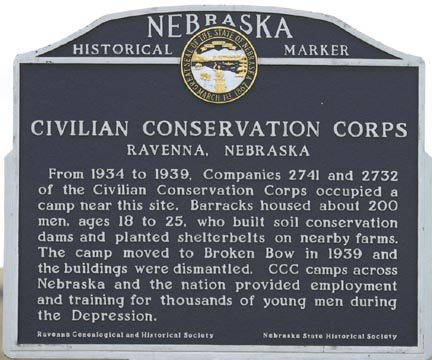
Highway 2, 1 mile southeast of Ravenna     PHOTO

    From 1934 to 1939, Companies 2741 and 2732 of the Civilian Conservation Corps occupied a camp near this site. Barracks housed about 200 men, ages 18 to 25, who built soil conservation dams and planted shelterbelts on nearby farms. The camp moved to Broken Bow in 1939 and the building were dismantled. CCC camps across Nebraska and the nation provided employment and training for thousands of young men during the Depression.

Ravenna Genealogical and Historical Society
Nebraska State Historical Society

line

KEARNEY COTTON MILL
U S Highway 30 west of Kearney     PHOTO

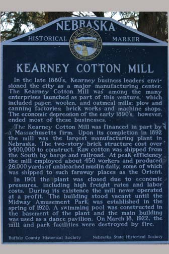
In the late 1880's, Kearney business leaders envisioned the city as a major manufacturing center. The Kearney Cotton Mill was among the many enterprises launched as part of this venture, which included paper, woolen, and oatmeal mills; plow and canning factories; brick works and machine shops. The economic depression of the early 1890's, however, ended most of these businesses.

The Kearney Cotton Mill was financed in part by a Massachusetts firm. Upon its completion in 1892 the mill was the largest manufacturing plant in Nebraska. The two-story brick structure cost over $400,000 to construct. Raw cotton was shipped from the South by barge and railroad. At peak efficiency the mill employed about 450 workers and produced 26,000 yards of unbleached muslin daily, some of which was shipped to such faraway places as the Orient.

In 1901 the plant was closed due to economic pressures, including high freight rates and labor costs. During its existence the mill never operated at a profit. The building stood vacant until the Midway Amusement Park was established in the spring of 1920. A swimming pool was constructed in the basement of the plant and the main building was used as a dance pavilion. On March 18, 1922, the mill and park facilities were destroyed by fire.

Buffalo County Historical Society
Nebraska State Historical Society
US 30, west of Kearney - Buffalo County

line

ELM CREEK
At library, Tyler St., Elm Creek     PHOTO

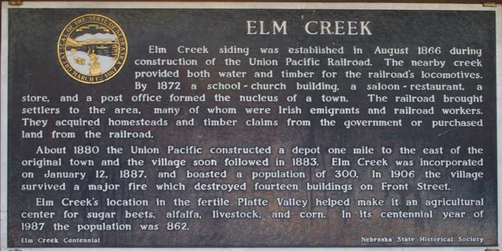
Elm Creek siding was established in August 1866 during construction of the Union Pacific Railroad. The nearby creek provided both water and timber for the railroad's locomotives. By 1872 a school-church building, a saloon-restaurant, a store, and a post office formed the nucleus of a town. The railroad brought settlers to the area, many of whom were Irish emigrants and railroad workers. They acquired homesteads and timber claims from the government or purchased land from the railroad.

About 1880 the Union Pacific constructed a depot one mile to the east of the original town and the village soon followed in 1883. Elm Creek was incorporated on January 12, 1887, and boasted a population of 300. In 1906 the village survived a major fire which destroyed fourteen buildings on Front Street.

Elm Creek's location in the fertile Platte Valley helped make it an agricultural center for sugar beets, alfalfa, livestock, and corn. In its centennial year of 1987 the population was 862.

Elm Creek Centennial
Nebraska State Historical Society
Library lawn on Tyler St., Elm Creek

line

POST SOUTH LOUP FORK, "Fort Banishment"
Highway 2, 1 mile southeast of Ravenna     PHOTO

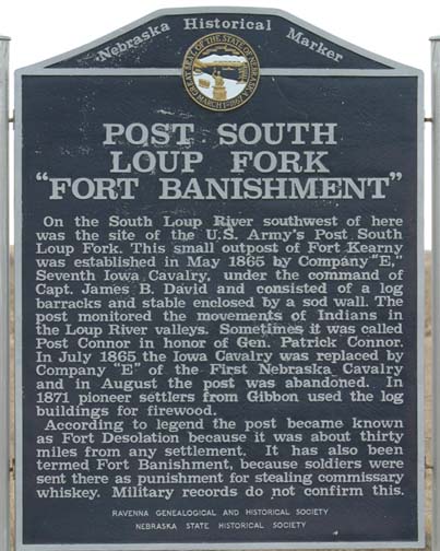
On the South Loup River southwest of here was the site of the U.S. Army's Post South Loup Fork. This small outpost of Fort Kearny was established in May 1865 by Company "E," Seventh Iowa Cavalry, under the command of Capt. James B. David and consisted of a log barracks and stable enclosed by a sod wall. The post monitored the movements of Indians in the Loup River valleys. Sometimes it was called Post Connor in honor of Gen. Patrick Connor. In July 1865 the Iowa Cavalry was replaced by Company "E" of the First Nebraska Cavalry and in August the post was abandoned. In 1871 pioneer settlers from Gibbon used the log buildings for firewood.

According to legend the post became known as Fort Desolation because it was about thirty miles from any settlement. It has also been termed Fort Banishment, because soldiers were sent there at punishment for stealing commissary whiskey. Military records do not confirm this.

Ravenna Genealogical and Historical Society
Nebraska State Historical Society

line

1871 GIBBON 1971
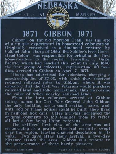
Access road, Windmill State wayside area off I-80, 3 miles South of Gibbon     PHOTO

Gibbon, on the old Mormon Trail, was the site of a unique experiment in homestead colonization. Originally conceived as a financial venture by Colonel John Thorp of Ohio, the Soldier's Free Homestead Colony was responsible for bringing the first homesteaders to the region. Traveling by Union Pacific, which had reached this point in July 1866, the first group of colonists, representing 80 families, arrived in Gibbon on April 7, 1871.

Thorp had advertised for colonists, charging a membership fee of $2.00, with which they received reduced railroad rates to Gibbon, where it was expected that the Civil War Veterans would purchase railroad land and take homesteads, thus increasing the value of other nearby railroad lands.

When the first colonists arrived at Gibbon siding, named for Civil War General John Gibbon, the only building was a small section house, and, until sod or frame homes could be built, they lived in railroad box cars. Later arrivals increased the original colonists to 129 families from 15 states, all but a few being Union veterans.

The settlers' first view of the area was not encouraging as a prairie fire had recently swept over the region, leaving charred desolation in its wake. Two days after their arrival, a two-day blizzard struck the area. It is a tribute to the perseverance of these hardy pioneers that only one colonist failed to file a homestead claim.

Gibbon Lions Club
Nebraska State Historical Society

line

THE GREAT PLAINS
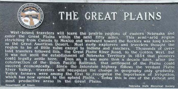
Westbound I-80 rest area, Kearney     PHOTO

West-bound travelers will leave the prairie regions of eastern Nebraska and enter the Great Plains within the next fifty miles. This semi-arid region stretching from Canada to Mexico and westward toward the Rockies was long known as the Great American Desert. Most early explorers and travelers thought the region to be of little value except to Indians and ranchers. Thousands of overland travelers followed this, the Great Platte River Road, to the Golden West, but it was not until the establishment of Nebraska Territory in 1854 that pioneers could legally settle here.

Even so, it was more than a decade later, after the construction of the Union Pacific Railroad, that settlement of the Plains could succeed economically. Since the Interstate highway follows the verdant Platte River Valley, travelers will recognize the change in geography only gradually. Valley farmers were among the first to recognize the importance of irrigation, which has now spread to the upland Plains. Today this is one of the richest and most productive areas in the Great Plains.

Department of Roads
Nebraska State Historical Society
Kearney Rest Area, I-80 W

line

HISTORIC KEARNEY
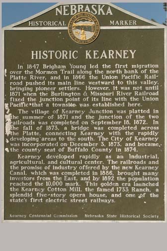
Centennial Park, 11th St., Kearney     PHOTO

In 1847 Brigham Young led the first migration over the Mormon Trail along the north bank of the Platte River, and in 1866 the Union Pacific Railroad pushed its main line westward to this valley, brining pioneer settlers. However, it was not until 1871 when the Burlington & Missouri River Railroad fixed the junction point of its line with the Union Pacific that a townsite was established here.

The village of Kearney Junction was platted in the summer of 1871 and the junction of the tow railroads was completed on September 18, 1872. In the fall of 1873, a bridge was completed across the Platte, connecting Kearney with the rapidly developing areas to the south. The City of Kearney was incorporated on December 3, 1873, and became the county seat of Buffalo County in 1874.

Kearney developed rapidly as an industrial, agricultural, and cultural center. The railroads and the promise of industy offered by the new Kearney Canal, which was completed in 1886, brought many investors from the East, and by 1892 the population reached the 10,000 mark. This golden era launched the Kearney Cotton Mill, the famed 1733 Ranch, a splendid five-story opera house, and one of the state's first electric street railways.

Kearney Centennial Commission
Nebraska State Historical Society

line

JOSEPH E. JOHNSON AND THE HUNTSMAN'S ECHO
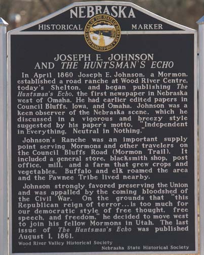
Railroad Park, U. S. 30, Shelton    PHOTO

In April 1860 Josesph E. Johnson, a Mormon, established a road ranche at Wood River Centre, today's Shelton, and began publishing The Huntsman's Echo, the first newspaper in Nebraska west of Omaha. He had earlier edited papers in Council Bluffs, Iowa, and Omaha. Johnson was a keen observer of the Nebraska scene, which he discussed in a vigorous and breezy style suggested by his paper's motto, "Independent in Everything, Neutral in Nothing."

Johnson's Ranche was an important supply point serving Mormons and other travelers on the Council Bluffs Road (Mormon Trail). It included a general store, blacksmith shop, post office, mill and a farm that grew crops and vegetables. Buffalo and elk roamed the area and the Pawnee Tribe lived nearby.

Johnson strongly favored preserving the Union and was appalled by the coming bloodshed of the Civil War. On grounds that "this Republican reign of terror…is too much for our democratic style of free thought, free speech, and freedom," he decided to move west to join his fellow Mormon in Utah. The last issue of The Huntsman's Echo was published August 1, 1861.

Wood River Valley Historical Society
Nebraska State Historical Society

line

KEARNEY - FORT KEARNY
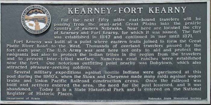
Eastbound I-80 rest area, Kearney    PHOTO

For the next fifty miles east-bound travelers will be passing from the semi-arid Great Plains into the prairie country of eastern Nebraska. Near here are located the city of Kearney and Fort Kearny, for which it was named. The fort was established in 1847 and continued in use until 1871.

Fort Kearny was built at a point where eastern trails joined to form the Great Platte River Road to the West. Thousands of overland travelers passed by the fort each year. The U.S. Army was sent here not only to aid and protect the emigrants but also to protect the Indian tribes in the region from the travelers and to prevent inter-tribal warfare. Numerous road ranches were established near the fort. One notorious outfitting point nearby was Dobytown, which also attracted pleasure-seeking soldiers.

Several military expeditions against hostile Indians were garrisoned at this post during the 1860's, when the Sioux and Cheyenne made many raids against wagon trains and Union Pacific Railroad construction crews. Once the railroad was built and settlers entered the area, the need for the post lessened, and it was abandoned. Today it is a State Historical Park and is entered on the National Register of Historic Places.

Department of Roads
Nebraska State Historical Society

line

NEBRASKA CENTRE - BOYD RANCH
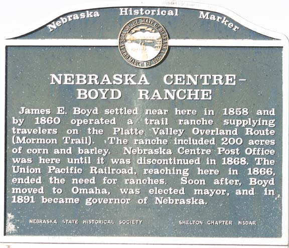
U.S. 30, 1.75 miles west of Gibbon     PHOTO

James E. Boyd settled near here in 1858 and by 1860 operated a trail ranche supplying travelers on the Platte Valley Overland Route (Mormon Trail). The ranche included 200 acres of corn and barley. Nebraska Centre Post Office was here until it was discontinued in 1868. The Union Pacific Railroad, reaching here in 1866, ended the need for ranches. Soon after, Boyd moved to Omaha, was elected mayor, and in 1891 became governor of Nebraska.

Nebraska State Historical Society
Shelton Chapter NSDAR

line

PLEASANTON BRANCH UPRR
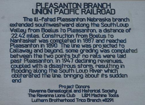
Highway 2, 1 mile southeast of Ravenna    PHOTO

The ill-fated Pleasanton Nebraska branch extended southwestward along the South Loup Valley from Boelus to Pleasanton, a distance of 22.42 miles. Construction from Boelus to Nantasket was completed in 1887 and reached Pleasanton in 1890. The line was projected to Callaway and beyond, some grading was completed between the two points but no rails were laid past Pleasanton. In 1947 declining revenues, coupled with a disastrous storm, resulting in flooding along the South Loup River which obliterated the line, bringing about its sudden end.

Project Donors:
Ravenna Genealogical and Historical Society
The Ravenna Lions Club
L & M Machine Tools
Luthern Brotherhood Trico Branch #8291

line

UNIVERSITY OF NEBRASKA AT KEARNEY
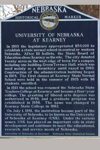
UNK campus, east end    PHOTO

In 1903 the legislature appropriated $50,000 to establish a state normal school in central or western Nebraska. After 111 ballots, the State Board of Education chose Kearney as the site. The city donated twenty acres on the west efge of town for a campus, including on building, Green Terrace Hall, which was used maily as a dormitory until razed in 1960. Construction of the admininstration building began in 1904. The first classes at Kearney State Normal School were held in the summer of 1905 with 96 students enrolled.

In 1921 the school was renamed the Nebraska State Teachers College at Kearney and became a four-year college. The granting of liberal arts degrees was authorized in 1949, and a graduate program was established in 1956. The name was changed to Kearney State College in 1963.

On July 1, 1991, the institution became part of the University of Nebraska, to be known as the University of Nebraska at Kearney (UNK). Under its various names, UNK has played an important role in state development and continues to meet the education, research and service need of Nebraska.

University of Nebraska at Kearney
Nebraska State Historical Society

line

THE WATSON RANCH     PHOTO

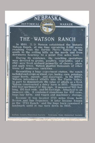
In 1888, H. D. Watson established the historic Watson Ranch, at one time containing 8,000 acres, reaching from the fertile Platte Valley on the south to the rolling hills on the north and from downtown Kearney to a point five miles west.

During its existence, the ranching operations were devoted to grains, poultry, vegetables, and a 250-acre fruit orchard primarily of cherry, plum, and apple trees. Watson planted thousands of other trees of numerous varieties.

Resembling a huge experiment station, the ranch included such crops as wheat, rye, barley, corn, potatoes, sugar beets, squash, and asparagus. In the 1890's, Watson introduced alfalfa into the Platte Valley. In part to demonstrate the value of alfalfa as a feed, Watson constructed a dairy barn in 1900. Standing 650 feet northwest of this sign, it measured 500 feet long, 100 feet wide, and 56 feet high. Attached to an immense silo, it contained stanchions for 400 cows, huge hay lofts, and wagon and machinery storage.

Because it was located 1,733 miles from both Boston and San Francisco, it later became known as the "1733 Ranch," and the huge barn remained a landmark until it was torn down in 1935.

Buffalo County Historical Society
Nebraska State Historical Society
Hwy. 30, west of Kearney

line

buffaloMain page